
A BRIEF INTRODUCTION TO THE
PREHISTORY AND HISTORY OF THE PAGOSA AREA
12,000 – 8000 yrs B.C. | 8000 B.P. to A.D. 1 | AD 1 – 600 | 17th Century | 1800s |
Information adapted from A Brief Introduction to the Prehistory and History of the Durango Area, by Ross S. Curtis, Durango Archaeological Consultants. Sourced from DurangoDowntown.com
Introduction
The Pagosa Springs area is rich in natural resources, and the presence of abundant water, fertile soil, and a variety of plant and animal resources has made it an ideal area for human occupation going back almost 10,000 years. The area has played host to Paleo-Indian big game hunters, Archaic hunters and gatherers, Anasazi farmers, nomadic Utes, Spanish explorers, trappers and traders, miners, homesteaders, and others with a variety of dreams. People have been drawn to the area for it’s natural beauty, and for it’s economic opportunities. Through the efforts of archaeologists, historians, and others it has been possible chart the prehistoric and historic development of the area, and see what effects man has had on the land. By examining the history and prehistory of the area, we can see what has happened in the past, and this can help us to see where we may be going in the future. By knowing what has happened before us, we can better plan and manage our future.
Paleo-Indian
The first evidence for human occupation in the Southwest Colorado area is limited remains of Paleo-Indian big game hunting peoples represented primarily by isolated projectile points (ca. 12,000-8000 years BC). This period is generally accepted as the first occupation of the American Southwest, and is characterized by a mobile lifestyle following herds of bison and doing additional hunting and gathering activities. Other areas of Colorado such as the San Luis Valley of Eastern Colorado were more heavily occupied during this period and contain sites with numerous artifacts and cultural features. Similar sites with substantial cultural remains from the Paleo-Indian Period have not been found in the Pagosa Springs Area, but the presence of isolated projectile points from the area indicates a limited occupation during the period, and there could be more substantial sites present. To date the projectile points have been confined primarily to the Plano Period of approximately 8000 years BP, but a Clovis style projectile point(8,000-10,00 BP) was recently found south of Durango above the Animas River indicating earlier groups were present in the general area.
Archaic
Sites attributed to the various stages of the later Archaic Period (8000 BP To AD 1) are more numerous in the Southwest Colorado area. The generalized hunting and gathering economy of the Archaic Period, involved a mobile lifestyle where wild plants were harvested, and animals were hunted in seasonal rounds. Site types attributed to the Archaic Period include stone tool material procurement areas, stone toll manufacturing and reduction areas, open camps defined by flaked stone scatters with no architecture but occasional surface features such as hearths, and rock shelters. Sites were probably occupied for a short time, although rock shelters were used on a more regular basis. Archaic sites frequently occur at a variety of different elevations and varied environmental settings. There are a substantial numbers of Middle and Late Archaic sites, and fewer Early Archaic sites from the Durango area.
By the end of the Archaic Period (1000-B.C-A.D. 1) it appears that sites become more permanent with the addition of structures such as shallow pit houses. These more permanent sites may be related to the introduction of agriculture to the Four Corners Region and the integration of domesticated plants to the subsistence rounds. The adoption of agriculture and the resulting pattern of less mobility and more permanent sites is generally associated with the later Anasazi Basketmaker II Period (AD 1-600), but there are indications that the pattern may have begun even earlier in the Late Archaic Period.
Formative-Anasazi
By AD 1 agriculture in the form of domesticated plants were introduced to the economy of the prehistoric inhabitants of the Four Corners Region, and other cultural changes occurred which have been previously attributed to the Formative Period. In the Durango area, this is expressed as the beginning of the well known Anasazi Tradition. The first identifiable period associated with this tradition is the Basketmaker II Period (A.D.1-600). Basketmaker II sites are defined by the presence of small pit house villages of 1-4 shallow, round-to-oval shaped structures; the presence of corn and other domesticated plants; the use of storage pits, and the absence of ceramic artifacts. This period represents the first well defined farming period in the region.
Early archaeological investigations in the Durango area in the 1930s by Helen Sloan Daniels, Zeke Flora, and Earl Morris defined the Basketmaker II occupation in the area based on excavations near the fairgrounds, Crestview, and in the Falls Creek area north of Durango. These excavations showed pithouse village sites with permanence, domesticated plants, and a lack of ceramics. Later studies in the Durango area have further defined the nature of the Basketmaker II occupation through excavations in the Bodo Area as part of the Uranium Mill Tailings Removal Project, and extensive survey in Ridges Basin as part of the proposed Animas La Plata Project. Basketmaker II sites excavated in the Durango area date mostly from the period of AD 1-400 (based on tree ring and carbon 14 dates), but there are a few sites that are dated to the later half of the period (A.D 400-600). Basketmaker II development in the Durango area appears to coincide with a cycle of increased and then decreased effective moisture (rainfall) beginning in AD 100 and ending between A. D. 250-300. I appears that during this period the Durango area was a good place to be a farmer.
The second well documented period of Formative or Anasazi occupation in the Four Corners region is the Basketmaker III Period (AD 600-750). This period represents an elaboration of the sedentary agricultural patterns (permanent habitation sites with storage features and domesticated plants) established during the Basketmaker II Period. Sites attributed to this period include habitations with one or more pit houses along with associated storage facilities and refuse. The pithouses are generally large (ca. 5 m diameter) with a depth of one to two meters. A hallmark of the period was the introduction of pottery into the material culture of the Anasazi. This pottery is generally plain gray, with some simple painted decoration. The Basketmaker III Period is well represented in the Four Corners Region in such places as Cortez and Dove Creek, but only the later half of the period (AD 700-750) is represented in the sites previously dated in Durango at Falls Creek, Bodo Canyon, and a few other areas. The terraces above the Animas River in Crestview and near the La Plata County Fairgrounds were areas used by Anasazi farmers during this period.
The Anasazi Pueblo I Period (AD 750-900) represent the first period in which substantial surface architecture is present. Slab lined adobe surface rooms are found in association with pit houses. Distinct site structure can be identified during this period with pit houses surrounded by adobe rooms, and associated trash middens often located to the south. Some large sites have been identified that contain many rooms and associated pit houses. The Anasazi continued to practice agriculture, and many of the larger sites are found in areas between an elevation of 6200-7200 ft where optimal dry farming rainfall occurs.
In the Durango area, the late Basketmaker III to Pueblo I transition appears to represent the height of the Anasazi or Formative Period occupation. There are many sites dated to this period in the Ridges Basin and Bodo areas. The sites vary from large aggregated villages with many pit houses and surface rooms, to small hamlets containing a single pithouse and a few rooms. By the end of the Pueblo I Period it appears that the Durango area is abandoned by the Anasazi. It has been suggested that climatic fluctuations and unreliable rainfall patterns may have made the area a poor place for farming, resulting in a movement of the population to more favorable areas such as Montezuma County, Colorado or Northwest New Mexico.
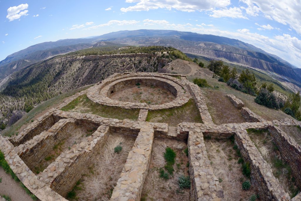
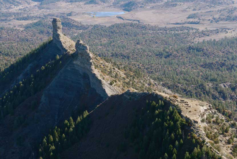
The final florescence of the Formative or Anasazi occupation of the Four Corners area is the Pueblo II (AD 900-1100) and Pueblo III (AD 1100-1300) Periods. This period is manifest in the large aggregated sites of several hundred masonry rooms and kivas found at Chaco Canyon, Mesa Verde, Yellow Jacket, and all across the Great Sage Plain of Montezuma County. There is very little evidence of late Anasazi occupation in the Durango area, with only a few temporary sites found. An anomaly during this period is the substantial late Anasazi site found at Chimney Rock which may represent a regional trade center.
Remaining historical information courtesy of ArchuletaCounty.org
Ute and Navajo
Following the Anasazi were the Navajo, Ute and Apache peoples who have lived and hunted in the area for centuries. Revered by the Indians, the Pagosa (a Ute word meaning ‘healing’ or ‘boiling water’) hot springs were frequented by many of the tribes. In 1848, Mexico ceded the area to the United States. The U.S. Government then established relations with the Indians and through a series of Treaties “bought” most of their land. In the Brunot Treaty of 1873, the Southern Ute Reservation was established in its present location.
Anglo-American
In 1859, the U.S. Army sent out an expedition through the Archuleta County area headed by Captain John Macomb, and soon after in 1860 gold was discovered in the San Juan Mountains. For the next 30 years, prospectors and settlers poured in to the area. In 1878, Fort Lewis was established along the San Juan River next to the great Pagosa Hot springs to protect settlers and travelers from the Indians. With Calvary troops, cowboys and Indians, gunfights and stagecoach holdups, Archuleta County was the embodiment of the Wild West.
Hispanic settlers reached the area about the same time as Anglo settlers. They settled the southern part of the county along the rivers. Hispanic communities such as Trujillo, Juanita, Pagosa Junction, and Carracas were settled with the arrival of the Denver & Rio Grande Railroad in 1881.
Archuleta County was created by the Colorado legislature on April 14, 1885, out of western Conejos County. It was named for J. M. Archuleta, “head of one of the old Spanish families of New Mexico”, and in honor of Antonio D. Archuleta, who was the Senator from Conejos County at the time. The Town of Pagosa Springs, which grew around Fort Lewis and remained after the fort moved west, was platted and surveyed in 1883 and incorporated in 1891. It remains the only incorporated town in the county.
The growth of cattle and sheep ranching, as well as the development of the lumber industry, led to a booming economy in the 1890’s and helped to bring the railroad to Pagosa Springs in 1900. With the advent of the railroad running between Silverton, Durango, Chama and points east along the southern boundary of the county, the lumber industry flourished and became the dominant sector of the economy. The railroad also boosted ranching by providing a practical way to ship cattle and sheep to market.
On August 21, 1916 a new highway built by the State of Colorado over Wolf Creek Pass was opened. Along with the new modern highway, came electricity and the telephone. The Old West was gone. The lumber boom lasted almost into the 1920’s, by which time the easily accessible timber had all been logged. Following shortly after was the Great Depression and World War II. Many of the rural residents of the County were forced to move either into town or further away out of the County to work in defense manufacturing plants.
In the 1970’s, the Pagosa Springs area and Archuleta County, became a beacon for land developers. With all the beautiful scenic panoramas of mountains, forests and streams, buyers with extra money to spend came from all around the Country and helped grow Archuleta County into the unique experience you have today.

